Posts

Samson in Branson

Image
At 1:30 PM on Wednesday, December 19th, my bride and I were off for Branson for a quick one night stay. Samson was showing at the Sight and Sound Theater and we were going to see it this evening. Driving nonstop it took us 3 hours and 15 minutes. After arriving at our motel we settled in, had a snack dinner that we brought with us, and walked laps around the parking lot. The snack did not quite satisfy Chris, who needed some fries. We drove to McDonald's where Chris scored her fries while I enjoyed a chocolate shake. We arrived at Sight and Sound Theater at 7:00 for the 7:30 showing of Samson. It was decorated for the Christmas season including a humongous fake Christmas tree outside the front doors. Warm pecans covered with sweet goodness were indulged in prior to the show. Samson was very entertaining. I enjoyed it despite the excessive singing and dancing and the fake fight scenes. Chris enjoyed it all. The sets were extraordinary. On Thursday, December 20th, we enjoyed a co...
Pershing State Park and Laclede, MO

Image
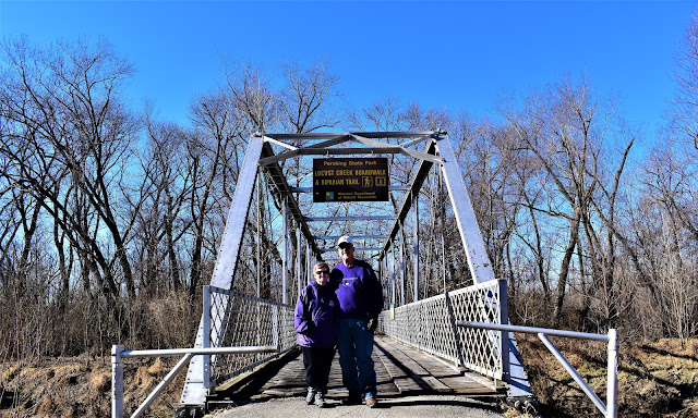
This morning Chris and I realized it was going to be a beautiful day so we decided to take advantage of it. For some time now we've been wanting to visit Pershing State Park near Laclede, MO, where there was a boardwalk walking trail through the forest. We decided to go for it. We took off late morning, I-35 north into Missouri and Hwy 36 eastbound. In Chillicothe, MO we stopped at Applebee's for lunch before our walk. About 20 miles east of Chillicothe on Hwy 139 we entered Pershing State Park and located the Locust Creek Boardwalk and Riparian Trail. It was a pretty area. During certain times of the year it is a wetlands area, thus the need for the boardwalk. I think we'll make a point to return sometime in a rainy season. After leaving the boardwalk trail we walked the very short Scout Trail. We also visited the War Angel statue. The history of the artist is very interesting! After leaving the park we visited Laclede, MO to see General P...

Pacific Northwest II; Day 13

We left Goodland, KS at 9:20 central time and it was 29 degrees under blue clear skies. We drove east on I-70 to Abilene, where we had a lunch of fried chicken plus fixins at the Brookville Hotel ( LARRAPIN GOOD FRIED CHICKEN ). We've tried eating here multiple times before but couldn't because they were closed or we didn't want to wait the necessary amount of time. Today we walked right in and had lunch. It was very good and we brought home left-over chicken for another meal. The Brookville Hotel had a small gift shop in the lobby and Chris took advantage for a few Christmas gifts. Also, while at the hotel, I used my iPhone app to increase the temperature on our home thermostat so it would be nice and toasty when we arrived. It was the first time I used it away from home - and it worked. Back on I-70 eastbound, headed for home, we were listening to the K-State football game against KU. Just as we passed the exit for Manhattan the Wildcats sealed the win but it was clos...

Pacific Northwest II; Day 12

Image
It was a very relaxing morning indulging in the complimentary hotel breakfast and delaying check-out until 10:00. It was sunny and 36 degrees. Pikes Peak was looking down on us as we walked to our car in the parking lot. We drove to Garden of the Gods for a short invigorating walk. We could tell we were at altitude. We enjoyed another view of Pikes Peak behind Garden of the Gods. At 11:00 we visited with my cousin, Deb, and her husband, Jim. After lunch, some conversation and a photo op Chris and I hit the road eastbound. It was almost 3:00. We drove to Goodland, KS before we called it a night. It was 21 degrees in Goodland. Total mileage today was 194. The soak in the hotel hot tub before going to bed felt gooood. Click here to view the photos taken today:  Day12Pics

Pacific Northwest II; Day 11

Image
We started the morning in Price, UT and ended the day in Colorado Springs, CO; a 462 mile drive. It was 33 degrees when we left and it was in the 30’s when we arrived in the Springs. Our route was Hwy 6 south from Price to I-70 eastbound into Colorado. At Grand Junction we departed the interstate taking Hwy 50 eastbound. Hwy 285 took us north from Poncha Springs and at Hwy 24 we drove east to Colorado Springs. We stopped briefly at an I-70 visitor’s center in Fruita, CO. We enjoyed a lunch of Chinese food at the Panda Palace in Montrose, CO before driving on to Gunnison. Blue Mesa Reservoir was extremely low.  We gassed up the Sport in Gunnison before heading over Monarch Pass. There was quite a bit of snow at the pass but Hwy 50 was clear and dry. The mountain views from Monarch Pass to Colorado Springs are why I love driving in Colorado. Click on this link to see all the photos taken today:  Day11Pics

Pacific Northwest II; Day 10

Image
Blue clear skies all day today! It was 36 degrees when we departed but later in the morning it dropped to 30. The high temperature today was 53. We drove 456 miles from Boise to our destination in Price, UT. Interstate 84 took us south and east from Boise into Utah. I-15 took us southbound through Ogden, Salt Lake City, and numerous suburbs. At Spanish Fork we caught Hwy 6 south and east to Price. The following photo is the only one I took today. We were at a rest area on I-15 a little over 20 miles north of Ogden, UT. The mountains further south, behind Salt Lake City, are much more impressive but I did not stop on the interstate to take a photo. Instead, I found this photo online to show what they look like. We stopped in Layton, UT for lunch at the Outback Steakhouse. I was in the mood for a steak. As we were close to exiting I-15 and after we were on Hwy 6 Chris got to taking photos with her cell phone. You'll see the best of those by clicking on the link provided in ...

Pacific Northwest II; Day 9

Image
This day started like the last three. It was partly cloudy when we left our hotel in Gresham, OR but a short distance down Hwy 26 we were in rain again. It was 48 degrees. Hwy 26 was our route south and east in Oregon. A short jaunt on Hwy 201 took us to I-84 and southeast into Idaho to Boise (434 miles). Just south of where Hwy 26 intersected with Hwy 35 we could see the tip of Mt. Hood barely sticking out of the clouds. We were quite happy to be in sunshine and under blue skies. Further south on 26 we saw more snow capped peaks to the west. We enjoyed lunch at The Outpost in John Day, OR. Then we walked around town taking in the sights. The scenery along Hwy 26 was enjoyable. We arrived at our hotel in Boise, ID later than we would prefer. It was 6:30 and dark! Time to rest up for tomorrow. Life is good! Click on this link to see all photos taken today:  Day9Pics