Posts

Showing posts from July, 2013

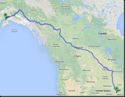
ALASKA; Day 17; July 31, 2013

Image
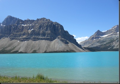
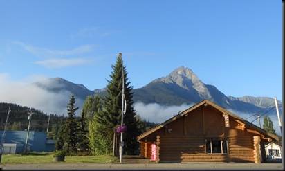
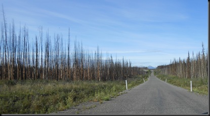
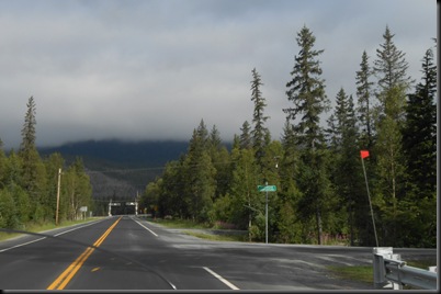
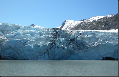
There was a tour bus at our motel last night full of Asian teenagers and their chaperons.  They were to be partaking of the continental breakfast from 6:00 to 7:00, so we arrived at 5:50 to beat the rush.  We were on the road at 6:40.  It was 42 degrees under blue clear skies. We rode north a short distance back north to Hwy 16 and then east through the Mount Robson Park into Jasper and Jasper National Park.  From Jasper we rode south on Hwy 93, also known as the Icefields Parkway, past the Columbia Icefield and through Banff National Park.  All of this is within the Canadian Rocky Mountains.  It was beautiful scenery and we made numerous stops for photos. Gary was in this area seven or eight years ago and he said the Athabasca Glacier has receded considerably in that time. We tried to see Lake Louise.  The people were a-hole to elbow and parking was packed.  Folks were parking along the road a mile from the lake.  We decided to pass.  On the way  down from the parking area we did

ALASKA; Day 16; July 30, 2013

Image
HAPPY BIRTHDAY to Eric, my oldest son, who turns 36 today! Before leaving New Hazelton we had breakfast at the New Hazelton Café.  A small Asian man was the waiter and cook.  A one-man operation until his woman showed up.  It was funny – he did not understand the concept of eggs being cooked over medium.  Our choice was sunny side up or scrambled.  It was a good breakfast despite the limited egg choices. New Hazelton was in or near the mountains, which were visible as we rode eastbound on Hwy 16.  The mountain scenery gave way to farm land (a lot of hay fields).  We also saw a lot of log trucks and a large saw mill near Vanderhoof, BC.  After gassing up in Vanderhoof we continued eastbound on 16 to Prince George where we made a WalMart stop. East of Prince George we rode into forest with mountain views.  The forest consisted of very tall pine trees.  A road-side sign identified the forest as an “Ancient Forest”.  A sign at a rest stop said some of the trees in the forest were 1,0

ALASKA; Day 15; July 29, 2013

Image
After a restaurant breakfast at the hotel we departed Watson Lake, Yukon Territory at 7:30.  It was 57 degrees.  We back-tracked westbound on the Alaska Highway about 15 miles to Hwy 37 south – an interesting road.  As you can tell from the pictures there were no lane markings.  The first 20 plus miles on this highway were through burned forest land.  The road was every bit as rough as the Alaska Highway. As we neared the mountains the road smoothed out some and after Dease Lake it was absolutely civilized – lane markings and all.  We stopped along the highway for a snack lunch and a break.  By pure chance we found out we were next to a gravel runway used by a tour service so we saw and airplane take off and a couple helicopters come and go. Gas (petrol) was an adventure.  We passed a sign that said no services would be available for 158 kilometers.  We figured we’d have enough gas given that distance.  After Larry obtained some information from some local native Canadians and Gary

ALASKA; Day 14; July 28, 2013

We left Ida’s Motel (the rooms were acceptable but the management/staff left much to be desired) at 7:05 and it was 55 degrees under cloudy skies.  It looked like we might get wet.  Our route today was a repeat of our route on July 19 (Alaska, Day 5) but in the opposite direction. We stopped for gas and breakfast at Burwash Landing.  We would have eaten at Ida’s Motel but the room was hot and they were very much short staffed.  The staff they did have was slow and incompetent.  I think they were the owners.  It took us 15 minutes to gas up at their pumps. We made several other stops including Whitehorse, Teslin, a rest area and a “resort” along the road. Our lodging for the night was Andrea’s Hotel in Watson Lake.  We opted NOT to stay at the Air Force Academy (where we stayed last week) because it did not fit our bill.  We had a fair dinner at Andrea’s restaurant before calling it a night. We found out that quality lodging and dining on the Alaska Highway is difficult to impos

ALASKA; Day 13; July 27, 2013

Carl and I saw our better halves off at 3:30 in the morning.  They were on their way to the Anchorage airport to catch a 5:05 flight home.  It won’t be the same without them. We checked our tire pressure this morning and found them low.  We filled em up and were on the road at 7:30, eastbound on Hwy 1.  It was cloudy and 61 degrees.  We stopped in Palmer for gas and continued east.  The temperature dropped to 54 and we rode in and out of clouds (or fog?) as we went up and down in elevation. After 120 miles we were into the sunshine and we could see some of the glaciers on the mountain range to the south.  When we stopped in Glennallen for gas it was 68 degrees. Hwy 1 took us north to Tok where Larry did some last minute souvenir shopping and we gassed up again.  Then it was eastbound into Canada and their god-awful roads.  None of us were singled out to be searched this time!  We stopped in Beaver Creek and spent the night at Ida’s Motel after having a larrapin good pizza dinner

ALASKA; Day 12; July 26, 2012

Image
We left Homer at 8:15.  It was 59 degrees and cloudy.  It had rained in the night and we were wondering if we would get wet today.  Larry and Gary put on their rain suits to make sure we would NOT get wet. We rode Hwy 1 back to Anchorage.  We were back-tracking routes we’d already ridden so we didn’t take too many pictures.  The temperature dropped to 54 before rising to 66 when we arrived in Anchorage at about 1:15. We changed the oil in our motorcycles in the hotel parking lot and then delivered the used oil to a recycling facility in Anchorage.  The beasts were ready for the trip back home.  It was 70 degrees when we were changing oil. We had dinner at a nearby Mexican restaurant before retiring for the night.  We rode 235 miles today (224 according to Garmin). For pictures from today click on the following link: https://plus.google.com/photos/104542123131082631220/albums/5905093235972572225?authkey=CNvXi7ae5K2wxwE

ALASKA; Day 11; July 25, 2013

Image
We departed Seward, AK this morning at 9:15.  It was cloudy (low hanging clouds) and 59 degrees.  For awhile there was a fine mist hitting the windshield. We rode north on the Seward Highway (Hwy 9) to the Sterling Highway (Hwy 1) west and south to Homer, AK.  The skies cleared up as the day progressed.  It ended up being another beautiful day in paradise with a high in the low 70’s. We stopped in Kenai, AK for lunch, gas and to check out the Beluga whale lookout.  No whales were sighted but we saw numerous people dip-net fishing in the Kenai River where it empties into the Cook Inlet. We stopped at the Deep Creek State Recreation Area just off the Sterling Highway south of Ninilchik and enjoyed the view of the Cook Inlet with mountains on the other side.  I also saw a tractor ride into the water with a boat trailer for boats coming ashore.  The tractor would then pull the trailer, with boat aboard, into the parking lot.  It was a slick operation. Riding into Homer was absolute

ALASKA; Day 10; July 24, 2013

Image
We left the Dimond Center Hotel in Anchorage at 9:00 am and rode south on Hwy 1.  It was 66 degrees.  About the first 50 miles or so we were on the same route we rode on day 7 (July 21st) to the Portage Glacier tour and Whittier. We stopped a couple places for a break and for pictures.  At one location there was a worn path up a small hill and along a ridge.  The ridge overlooked a steep wooded ravine with a stream or river at the bottom. Our route took us out on the Kenai Peninsula.  We took the Hope cut-off and visited Hope, AK.  Route 9 then took us south through some pretty scenery . . . . to Seward, where we had a larrapin good lunch at Chinook’s Waterfront Restaurant.  The fresh fish was fantastic. We checked into our rooms at the Breeze Inn and had a little break before Carl, Marge, Chris and I rode and hiked up to Exit Glacier.  We thought we’d be able to touch the glacier but we were not allowed close enough. We rode into Seward so Marge and Chris could do a little sho

ALASKA; Day 9; July 23, 2013

Image
HAPPY BIRTHDAY to Carl, who turned 59 today! We left the Cedar Lodge this morning at 8:15 and rode 6 miles north to the entrance to Denali National Park.  It was mostly cloudy and 55 degrees.  After stopping at the visitor center and paying our fees we rode into the park as far as we could in/on privately owned vehicles.  They said it was 15 miles but it was less than that from the visitor center.  We stopped at the Savage Cabin and walked the short interpretive trail.  We saw NO wildlife while in Denali National Park until we stopped at the gift shop, where we saw a chipmunk foraging for food. Later, at a gas station nearby, an older couple who had been on a park bus tour of Denali National Park (they go deeper into the park) told us they saw bear, caribou, moose and Dall sheep. I guess that’s the price we pay for refusing to give up our rides for a park bus. From the park we rode south on Hwy 3 back to Anchorage.  Mt. McKinley was in full view again today, which was very fortunat

ALASKA; Day 8; July 22, 2013

Image
We left our hotel at 9:30 am.  It was 66 degrees under blue clear skies.  We rode Hwy 1 north.  Early in the trip, near the junction of Hwy 1 and Hwy 3, we saw a moose off the side of the highway.  We continued north on 1 to the Talkeetna turn-off.  The ladies did some shopping in Talkeetna and we had lunch at the West Rib (good chow).  We continued north on Hwy 1 to milepost 231 where we stopped at the Denali River Cabins and Cedar Lodge.  We stayed in the Cedar Lodge. I really enjoyed the views of Mt. McKinley and the weather really cooperated.  After our initial moose sighting we saw a group of 3 moose some distance off the road north of the Talkeetna turn-off. Another GREAT day! For pictures from today click on the following link: https://plus.google.com/photos/104542123131082631220/albums/5903671367580515713?authkey=CP3om_ifk8G3ygE

ALASKA; Day 7; July 21, 2013

Image
Gary, Carl, and Larry repaired Carl’s trailer. Then it was a tourist day.  At 1:15 pm we rode south on Hwy 1 about 50 miles to the turn off for Portage Glacier and Whittier.  Hwy 1 runs along the shore of the Cook Inlet with mountain views on the other side.  BEE-U-TEE-FULL!  We did the one hour Portage Glacier tour, which was very enjoyable. Since it was close by, and had been recommended to us by a fellow motorcyclist, we decided to ride through the 2.5 mile Whittier Tunnel to Whittier, AK.  The tunnel was built in 1941 to accommodate a train.  It was modified to include cars (and motorcycles) in 2001.  The train tracks go right down the middle of the tunnel and the tunnel is only wide enough for one car width.  Motorcyclists have to ride between the train track rails.  The speed limit is 25. We were not pulling our trailers and it would not be recommended for them. We had a great fish (halibut) and chips plus clam chowder lunch at the Fresh Catch Café in Whittier before riding

ALASKA; Day 6; July 20, 2013

Image
Today was quite a day!  We had a buffet breakfast at the hotel.  There was a light rain so I went to my motorcycle to get my rain gear.  I noticed that my stainless steel Coleman cooler (a gift from Deb & Tim) was gone . . . RIPPED OFF!  Gary had the idea it could have been kids looking for beer and he suggested looking around the grounds for the cooler.  We did and Gary found it behind an adjacent building.  The items inside had not been stolen (no beer).  So I strapped it back on the rack and I was good to go. As we started the bikes preparing to leave, Gary noticed that Carl had no running lights on his trailer.  His brake lights and turn signals did work, however, so it was decided the issue would be diagnosed later. Beaver Creek, Yukon is only 20 miles from the border so we were off to Alaska USA.  It was 52 degrees in light rain.  We immediately ran into construction and a wait. When we got moving again it was a wet muddy ride to the border.  The crossing this time was un

ALASKA; Day 5; July 19, 2013

Image
Regarding the Air Force Lodge, where we slept last night in Watson Lake, I forgot to mention something in yesterday’s blog entry.  The proprietor did not allow us (or anybody) to wear shoes or boots into his lodge.  We had to leave our shoes inside the front door.  This was to keep his place clean, which it was.  Larry was NOT happy about having to remove his shoes. We had breakfast at Bee Jay’s Café in Watson Lake and then visited the Sign Post Forest . . . . . before leaving town at 8:30 or so.  It was 57 degrees and  sunny.  A short distance out of town we ran into a construction zone.  So we were waiting again. The Alaska Highway treated us, again, to beautiful scenery. We rode west through Teslin and Whitehorse to Haines Junction.  The Alaska Highway (Hwy 1) runs west and north from Haines Junction paralleling a mountain range, which would be absolutely beautiful under blue clear skies.  It was pretty enough with the tops of the mountains in the clouds. Between Haines Juncti

ALASKA; Day 4; July 18, 2013

Image
Today we are riding the famous Alaska Highway.  We are leaving from Dawson Creek, BC, which is milepost 0 (starting point) of the Alaska Highway. After our complimentary breakfast at the motel (which was very good), refueling the hogs and icing down the coolers we were on the Alaska Highway by 6:40.  It was 59 degrees and clear.  The first 50 to 100 miles of the Alaska Highway were totally unimpressive with development, industrial areas, and farming – not what I expected.  After that, however, we rode into forest land and mountains.  At about 145 miles we stopped for gas along the Alaska Highway. We gassed up again in Ft. Nelson, BC and then had lunch at the Triple G Hideaway campground restaurant.  The food was very good and the staff was excellent.  We also gassed up at the Toad River Lodge and the Coal River Lodge. The ride was excellent with beautiful mountain scenery, wildflowers and wildlife viewing.  One of my goals this trip was to see a live wild bear.  I had 3 sightings

ALASKA; Day 3; July 17, 2013

Another long day of riding (with three more to go)!  We departed North Battleford, SK at 6:20 am under mostly sunny skies with a temperature of 52.  We rode into the Canadian province of Alberta, through the cities of Edmonton, Whitecourt and Grande Prairie, and into the province of British Columbia to Dawson Creek, where we stopped for the night at the Aurora Park Inn & Suites. We stopped for fuel in Maidstone (Saskatchewan), Edmonton, Whitecourt and Grande Prairie.  We also had lunch at Smitty’s in Whitecourt. It was a good day of riding except that the last 40 miles or so took us about an hour and a half due to several different construction zones.  Our mileage for the day was: 630 by the odometer; 609 by the Garmin GPS.  The high temperature was in the 80’s. Click on the following link for pictures from today: https://plus.google.com/photos/104542123131082631220/albums/5901783030030059633?authkey=CPa0sYjhrqis6wE It is time to clean up the dirty nasty motorcycle and turn

ALASKA; Day 2; July 16, 2013

Image
HAPPY B IRTHDAY to Bryan, my youngest son.  He turned 33 today. We blasted out of Jamestown, ND at 6:40 and it was 66 degrees.  A beautiful morning.  We rode north and west to Canada seeing some pretty scenery around Minot. We entered Canada at Portal, ND. As luck would have it, Larry and I were singled out for searches.  I was dog-sniffed and a Canadian customs agent searched my motorcycle and trailer.  Larry received the same treatment.  For some inexplicable reason, Gary and Carl were left alone.  Perhaps they checked every other vehicle.  I was the first one through and Larry was the third. Fortunately, they didn’t find all our contraband and they let us into Canada. We had lunch at a hole-in-the-wall establishment in Midale, Saskatchewan and then stopped for gas in Regina (rhymes with vagina), Saskatchewan.  While we were stopped in the parking lot a guy backed into Gary’s trailer causing minor damage.  Darned the bad luck. We rolled into North Battleford, Saskatchewan a

ALASKA; Day 1; July 15, 2013

Image
Today we embarked on a motorcycle trip that has been on my bucket list for some time.  I’m sure the same applies to my brother, Carl, who is making the trip too.  We are accompanied by two friends, Gary and Larry. We met at a Quick Trip in western Shawnee, KS at 6:00 am and actually departed at 6:05.  It was 67 degrees under mostly clear skies.  Carl was leading today and we booked it north on I-435 and I-29.  Our first stop was for gas in Council Bluffs, Iowa, about 190 miles north. At Sioux City Iowa we saw the Sergeant Charles Floyd Monument on a hill on the east side of I-29 ( http://www.nps.gov/nr/travel/lewisandclark/ser.htm ).  Floyd was the only member of the Lewis & Clark expedition that died during their journey. In Sioux Falls, SD we stopped again for gas and then had lunch at Marlin’s Family Restaurant. Just south of the North Dakota border we took an exit for Brown’s Valley.  It made me laugh as I thought about my grandson, Ben.  During Ben’s most recent visit