Posts

Showing posts from October, 2019

Florida; Day 1

Image
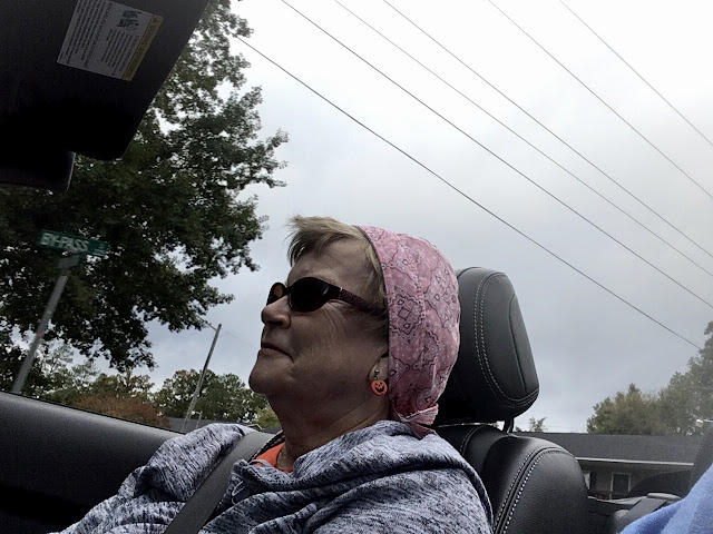
Having said our goodbyes to Ron and Cindy we rolled down the mountain near Hendersonville, NC at 7:30. It was 66 degrees and raining. Google maps were set to take us on back roads (no Interstate highways) to Clearwater, Florida. I followed Google's directions and made no attempt to record all the highways traveled. It rained all the way to Greenville, SC and most of the way it was a deluge. The highway was curvy and leaf covered, which made me anxious about the possibility of losing traction. The Poonie hung tough in the curves. It would have been a beautiful drive on a sunny day. Somewhere south of Greenville the rain stopped and in Greenwood, SC the top came down (75 degrees). It stayed down the rest of the day! Chris riding top down wearing her new do-rag We stopped briefly in Baker Creek State Park (South Carolina) so we could stretch our legs and do some walking. This park is on the banks of the Savannah River (Lake?), which is the border between South Carolina and G

North Carolina; Day 4

Image
Ron, Cindy, Chris, Charlie Another relaxing day on and around Ron & Cindy's mountain near Hendersonville, NC. We went to the Sky Top Orchard in Zirconia, NC, originally to get some apples, but in the end to get some donuts, apple butter and some other stuff. The ladies did a little shopping in Flat Rock and then again in Hendersonville. While the ladies were shopping in Flat Rock, Ron and I sat outside watching the traffic and drinking coffee and I ate a really good oatmeal raisin cookie. shopping in Flat Rock We enjoyed lunch at "A Day in the Country". I got some replacement windshield wipers for Poonie. Cindy fixed another LARRAPIN good dinner and we watched game 7 of the World Series (but maybe we went to bed before it was over???) It rained pretty much all day and it was foggy on the mountain. Temperatures were in the low 60's. Another excellent day. To see the few other photos taken today click on this link:  NCday4Pics

North Carolina; Day 3

Image
An enjoyable day was spent with Ron and Cindy. We woke up when we wanted, relaxed, napped and ate quite well. We also went to the Carl Sandburg Home National Historic Site in Flat Rock, NC where we visited the goat barn, viewed the home and walked around the lake. It was a beautiful area. Cindy and Chris eyeballing Carl Sandburg's home Ron, Chris and Cindy walking the path around the lake Cindy drove today and I have no idea how many miles it was but it wasn't much. The day started foggy (on the mountain, anyway), then turned cloudy, and later the sun peaked out a little bit. The low temperature was in the low 50's and the high in the low 60's. Supposed to rain tomorrow. To view all the photos taken today click on this link:  Day in Photos

North Carolina; Day 2

Image
Chris and I drove away (eastbound on I-40) from our hotel in Kingston Springs, TN at 8:10. It was foggy and 54 degrees. In a half hour we experienced the joy of driving through downtown Nashville. If I was smart I would have stopped on the east side of Tennessee yesterday evening. Burgess Falls State Park (southwest of Cookeville, TN) was our first stop of the day. We had a great time hiking, taking photos and just enjoying the beautiful outdoors. As you can see in the photo below there was still some fog above the river. It was lunch time when we left Burgess Falls State Park so we drove a short distance south and east on 135 and 111 to Sparta, TN, where we had some pulled pork at Jack's Top BBQ. From Sparta we drove 70 east to Crossville, where we caught I-40 eastbound. East of Knoxville we took I-26 east (going south) to Hendersonville and then back roads to Ron and Cindy's. They live in a beautiful house on top of a mountain west of Hendersonville. The view from t

North Carolina; Day 1

Image
This morning we said our goodbyes to Carl, Marge, Gary and Denah. The prior two days we were with them participating in Gary's Fall Ride. As they rode home to conclude Gary's ride, Chris and I were off for North Carolina to visit Chris' brother and his wife. We left Bentonville, AR at 8:00 under sunny skies with a temperature of 41. Our route today was simple. Interstate 49 south to Alma and then Interstate 40 east into Tennessee. We drove 534 miles and stopped just west of Nashville in Kingston Springs. The high temperature today was 62. As we drove south on I-49 we ran into some fog and low lying clouds. We drove into and out of the fog on down I-49 and eastbound on I-40. Eventually the off-and-on fog turned into clouds, which lasted the last of the trip. We stopped for gas and did some walking in Conway, AR and then enjoyed a soup and salad bar lunch in Forrest City, AR. After stopping for the day at 4:30 we were happy to learn that Gary, Denah, Carl and Marg

Gary's Fall Ride; Day 2

Image
Gary led us away from our hotel in Mountain Home, AR at 10:15 - in the rain. It was 50 degrees. Mel and Trish decided this morning to head back home so now there are only three couples. Our route today was Hwy 412 west to Springdale and then north on I-49 to Bentonville, where we stopped for the day. Gary would normally lead us on a circuitous route through Arkansas before arriving at our destination. Today we stopped at 1:30, having ridden/driven 144 miles through rain. Our high temp was in the low 50's. Along the way Chris was taking photos with her iPhone attempting to capture the fall foliage. This is difficult with clouds, rain, motion, and light reflected in the auto glass. But she did an admirable job. Despite the rain, portions of 412 made for a pretty drive. To see her pics click on this link:  FallColors As we were driving today, Chris was keeping track of the score of the K-State vs Oklahoma football game. I'm sure that Oklahoma was favored to win. At half time t

Gary's Fall Ride; Day 1

Image
We're off on Gary's fall ride to see the fall colors (hopefully) down in Arkansas. Also to enjoy the ride/drive and the company. This year there are four couples: Gary & Denah on their Honda Goldwing; Carl & Marge on their Honda Goldwing; Mel & Trish in their Cadillac; and Chris & I in our Mustang. All of us met at 151st & 69 Hwy in Overland Park at 9:00. Our route for the day was 69 south, back roads and 2 east to I-49 south, 7 east and 5 south to Mountain Home, AR. Along the way we stopped for lunch at Stewart's Restaurant located at the junction of Highways 7 and 5. Weather forecasts before we left had us convinced it would rain most of the day and, though it was cloudy all day, we only experienced very brief and very sparse sprinkles. Some fall color was observed along the way but not much. It was a cool/cold day, 41 when Chris and I left home and 42 when we left 151st and 69 Hwy. The high temp for the day was 53 in Mountain Home, AR, our d

Uncle Richard's Celebration of Life

Image
My uncle died recently and a funeral or "celebration of life" was scheduled for Saturday afternoon, October 19th. Chris and I decided to drive there and we were accompanied by brother, Carl, and his wife, Marge on their motorcycle. We would leave on Friday morning, take two days to get there and come back all the way on Sunday. Carl and Marge opted to take two days for the return trip. Friday, October 18, 2019 We left home at 8:10 under sunny skies. Our intention was to stay off the Interstate highways but we soon got it figured out that to be there in time on Saturday we'd need to utilize Interstates. So we were on back roads until we took Hwy 36 eastbound from just north of Braymer, MO into Hannibal, MO. In Hannibal we ate lunch at the Ole Planters Restaurant in the downtown area. Leaving Hannibal we drove east on I-72 all the way to Danville, IL. Below is a photo of Marge resting where we stopped for gas in Shelbyville, IN. She likes to stretch out when she can

Search for Aspen Gold; Day 7

Image
The last day of our trip and we are headed home. The aspens and mountains are in our rear view mirrors (a long way back). When we woke up it was wet outside and it still was when we left Goodland under cloudy and foggy skies with a temperature of 48. Skies provided off-and-on rain from mile post 113 all the way home. The hardest rain came around Topeka. As we were driving along I could tell that Chris was tired of reading and playing cards on her iPhone because she started taking photos of the Kansas scenery. We had been craving pizza for a few days so we decided to make a concerted effort to quench the crave today. A billboard advertised Martinelli's in Salina and it showed a picture of a guy with a pizza. So that was our lunch destination. It was in old downtown Salina and we enjoyed a LARRAPIN good pizza. pizza at Martinelli's Little Italy in Salina, KS As we approached Junction City, eastbound I-70 traffic came to a standstill. Eventually we were all funn

Search for Aspen Gold; Day 6

It was cloudy and 44 degrees when we left our hotel in Colorado Springs at 9:15. After gassing up we drove to Deb & Jim's house for a visit. Deb is my cousin and Jim is her hubby. We always enjoy our visits. There was also a scrumptious lunch involved. After solving most of the world's problems we left Deb & Jim's at 1:05. It was now 54 degrees. Our route today was 24 east to Limon and I-70 east to Goodland, where we arrived at 4:00. The temp had risen to a blistering 66 degrees. After a swim, a soak in the hot tub, and some boob-tube watching we called it a night. We drove 184 miles today and took no photos.

Search for Aspen Gold; Day 5

Image
It was 8:30, sunny and 52 degrees as we drove away northbound from Salida. We could still see smoke coming from the forest fire south of town. We got a later start today because I took Poonie to a car wash for a good cleaning. Our route today was 291 north, 285 north, 24 east, Teller County Road 1 south (from Florrisant to Cripple Creek), 67 north and 24 east. At Wilkerson Pass (9,507 feet altitude) we intended to stop to photograph a few orange aspen trees but the parking lot was closed. We parked just outside and walked in for the pics. I intended for our first stop to be Cripple Creek but just north of Florrisant we came upon the Florrisant Fossil Beds National Monument. We never visited it before so we stopped. They say about 35 million years ago there was a redwood forest at this location. What is left today are some petrified redwood tree stumps. They have also found numerous fish, animal, and insect fossils in the area. We walked a one mile loop to see several of the

Search for Aspen Gold; Day 4

Image
We left Dillon, Colorado this morning at 8:00 under sunny skies with a temperature of 44. Another BEAUTIFUL day! Our route today was I-70 west to exit 195, 91 south, 24 east, 82 west to Independence Pass, 82 back east to 24 east, 285 south and 291 south to our destination of Salida, CO. Beautiful stands of golden Aspen were seen along 91 on the way to Leadville. Our first stop was Turquoise Lake just outside Leadville, where we drove around the lake, and stopped to take a few photos. It was a beautiful area but we were surprised to see they were doing some logging there. We did some lollygagging, shopping and lunching in Leadville, at 10,000 feet elevation. We enjoyed some fried chicken at the Golden Burro Cafe. From Leadville we drove to the top of Independence Pass, where turned around and headed back east. At the pass we put the top down (it was 53 degrees) and it stayed down almost all the way to Salida. Historic Twin Lakes, Colorado is located east of Independe