Posts

Showing posts from 2021

Eastern Kansas Loop Drive

Image
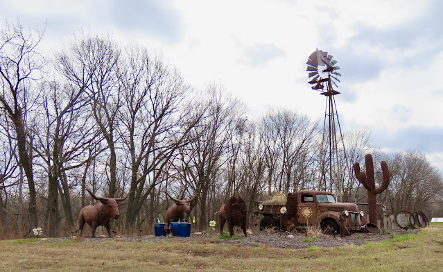
Chris and I decided several days ago, seeing warm temperatures forecast for today, to take a drive for lunch. We anticipated a top-down drive - in December! We left home at 10:40AM. It was 71 degrees but it was so blasted windy we left the top up on our Mustang convertible. Wind gusts up to 60 mph were predicted. Our route today was I-435 north out of Shawnee; Hwy 5 north and west to Lansing; Eisenhower Rd west; 187th St north; 92 west; 17 north; 192 west to Hwy 59; 16 west to Valley Falls; 4 south; 24 west; NW Topeka Blvd south; SW 10th Ave west to Bobo's Drive In Restaurant, 2300 SW 10th Ave, Topeka, KS. We stopped several times to take photographs. We found an interesting site along Hwy 4 a few miles south of Valley Falls. A 50 foot steeple was taken off the St. Bernard's Church in Wamego, KS and moved to this hill. We were able to walk up the hill and go inside. The burgers and tots at Bobo's Drive-In were delicious. Bobo's has been in operation since 1948. I would

Council Grove

Image
 Here it was, December 2nd, and temperatures were supposed to reach the 70's. A lunch drive to Council Grove, KS and the Flint Hills was in order. I departed Shawnee shortly after 10:00AM and drove west on old K-10 (83rd Street) to De Soto, KS where I dropped off a package to a friend. From De Soto the route was north across the Kansas River on Wyandotte Street, north on County Road 2 and then west on Golden Road, which turned north, where I took 32 westbound. East of Lawrence I jumped on 24 west. East of Topeka I caught 4 west, which joined up with I-70 west through Topeka to the west side. Highway 4 abandoned I-70 and routed me south and west through Dover and Eskridge all the way to Alta Vista, where I caught 177 south to Council Grove. I stopped a few places along the route to take pictures. It was 58 degrees when I left Shawnee and 72 when I arrived in Council Grove. The historic Hays House in Council Grove was my choice for lunch, where I enjoyed a LARRAPIN good meal of fried

Pawhuska; Day 3

Image
I really cooled off overnight. It was 32 degrees this morning and the car was covered with frost but there were blue clear skies. Our route today was 99 north; 56 east; 59 north to Lawrence; and 10 east to the KC area. The first stop today was one of those spur-of-the-moment deals. As we drove through Sedan, KS we spotted an interesting looking area just off the road. It was called The Hollow and it included an old school house, a gazebo and a wooden boardwalk through the area. They had it all wired for Christmas lights and we agreed it would be pretty lit up after dark. We did take one detour off 99 at 160 to drive about 5 miles east to Elk Falls, KS. The Elk River flows through Elk Falls, KS where there is Elk Falls (waterfall) with an old 1893 Pratt Truss bridge over the River. Also in Elk Falls is an Outhouse Grove with a sign advertising an Outhouse Tour on the Friday (tomorrow) and Saturday before Thanksgiving. In Olpe, KS we enjoyed a LARRAPIN good lunch at the Chicken House. We

Pawhuska; Day 2

Image
It cooled off overnight. Temperatures were in the low 50's and it was cloudy when we woke up this morning. After breakfast at the Mercantile we departed the cottage at 8:45. It was still cloudy and 54 degrees. As the day progressed the sun came and went but the temperature never topped 58 degrees and the wind really picked up. My plan was to drive through the Tallgrass Prairie Preserve just north of Pawhuska and photograph the bison said to be there. I envisioned a nice paved road weaving through the Preserve with bison grazing along the road. The reality was 12 miles of nasty, dusty, washboard, gravel road each way. The scenic viewpoints did provide decent views. When we arrived at the visitor's center it was closed and we had yet to see any bison. A sign on the door advised that this was bison roundup season and to see the bison we could drive two miles north (part of the 12 miles of gravel) to see the bison in the coral. Ends up the bison were about a half mile away from the

Pawhuska; Day 1

Image
 The town of Pawhuska, OK is named after Paw-His-Skah (White Hair), chief of the Thorny Valley People, one of five divisions of the Osage Nation that lived nearby. Pawhuska is also know for the Mercantile, opened by Ree Drummond of Pioneer Woman  fame. Pioneer Woman also has a hotel and event space. We have been wanting to eat (Charlie) and shop (Chris) at the Mercantile so we made a two-night trip of it. We left at 10:10AM under clear blue skies with a temperature in the high 50's or low 60's. Our route today way: I-35 south to Ottawa; 59 south to Garnett; 169 south to Chanute; 39 east (construction detour); 59 south (still on the detour); 47 west (more detour); 169 south (back on track); 160 west; 75 south; 166 west; 99 south into Oklahoma; and 60 west to Pawhuska. The detour added 22 miles or so to our trip. After stopping for a bathroom break in Chanute, KS we put the top down because it was 70 degrees. Chris forgot her doo-rag so she used one of my caps. We arrived in Pawh

Boys Fall Ride; Day 3

Image
At 6:30AM it was 70 degrees in Harrison, AR. Still 70 at 8:05, we departed our hotel westbound on Hwy 412/62. Our route today was 412/62 west; 65 north to Springfield, MO; I-44 west; 13 north to Clinton; 7 northwest to Harrisonville; I-49 north to Kansas City; I-435 west; 69 north; I-35 north to Shawnee. Traveling north on 65 in the area of Branson there was a sudden drop in temperature and the highway was wet in places. In the valleys the temperature dropped as low as 58 and on top of hills the temperature was in the low 60's. We stopped for gas at a Casey's just south of Springfield. On Hwy 13, 93 miles from home we stopped so I could put the top up on my car because it looked like we'd be getting into some rain. We eventually did. I arrived home at 12:15 where it was 67 degrees. We drove 245 miles. High temperature was in the low 70's. Click here to see the four photos taken today -  day 3 pics

Boy's Fall Ride; Day 2

Image
The day started at 8:20AM when we departed the hotel in Fort Smith, AR. It was 58 degrees under blue clear skies. I put the top down and it would stay down all day - SWEET! Highway 71 took us south out of Fort Smith and we caught Highway 10 eastbound. In Magazine, AR the road was blocked for a parade so we had about a 30 minute wait. I noticed a float carrying the Magazine High School class of 71, my graduation year. After the parade, and further east on Highway 10, we passed Magazine Mountain, the highest point in Arkansas. In this photo you can see the Lodge at Magazine Mountain on the crest of the mountain (hill?). We did not venture into Magazine Mountain State Park. At Danville, AR we turned south on Highway 27, which took us to Highway 270 east, which took us into Hot Springs, AR. For lunch we enjoyed brisket sandwiches at Stubby's BBQ in Hot Springs. Then it was Highway 7 northbound nonstop all the way to Harrison, AR, where we stopped for the day. There were a few places al

Boys Fall Ride; Day 1

Image
This trip was planned sort of spur-of-the-moment by Gary and Bill. I was fortunate in that they invited me along. My brother, Carl, was also invited but he had family obligations this weekend. Leaving home at 7:20AM it was a chilly 42. We met at the QT located at 151st Street and 69 Highway at 8:00AM. At about 8:15 we departed southbound on 69 Hwy and exited at 247th Street eastbound - which took us to Cleveland, MO. From there we took back roads to Archie, MO for breakfast at Mama's Kitchen. We left Archie southbound on I-49 at about 10:30 and it was still just 55 degrees. Near Joplin we took Hwy 59 south to Neosho, MO, where we stopped for gas and a short break. It was 66 degrees in Neosho so I put the top down and it stayed down the rest of the day. In Neosho we caught Hwy 60 west a short distance to I-49 southbound (again).  The interstate took us into Arkansas - and just south of Fayettville we exited to Hwy 71 southbound, the Boston Mountains Scenic Loop. At Alma, AR we caugh

Colorado Aspens; Day 6

Image
Last day of this trip - headed home. We left our hotel in McCook, NE at 8:15AM under sunny skies (again) with a temperature of 54 degrees. Our route was highway 83 south to Oberlin, KS; 36 east to Phillipsburg; 183 south; 9 east; 24 east to Manhattan; 177 south; I-70 east; I-435 south to Shawnee. I'm told that October is national breast cancer awareness month. As we were eastbound on 24 east of Downs, KS we passed these hay bales made to look like boobs. A short distance further east in Cawker City we passed the World's Largest Ball of Sisal Twine. Today it was disguised as a pumpkin. After lunch at Sonic in Manhattan we drove on home, arriving at 2:45PM. It was cloudy and 75 degrees. Our total mileage today was 377. To see all three photos taken today click on this link -  PHOTOS

Colorado Aspens; Day 5

Image
When we returned to our hotel yesterday we passed a large flower garden on the campus of Colorado State University. Doing a little research we found out it was the Annual Flower Trial Garden ( FlowerTrials ). After we left our hotel at 7:30AM we stopped to check it out. It was sunny and 45 degrees but the flowers were still beautiful. At 8:45AM we took off for McCook, Nebraska. Our route was Highway 14 east to Sterling, CO and then Highway 6 east to McCook. Along the way we saw several herds of pronghorn antelope off in the distance. In McCook we stopped at the Overland Trail Museum ( Museum ) and we stayed longer than I thought we would.  By the time we were done at the museum it was time for lunch. A lady in the museum suggested the J n L Cafe and it was very good. This was the only eating establishment we visited on this trip that did not appear to be short staffed. At 3:50PM (back in the central time zone) we arrived at our hotel in McCook, NE where it was sunny and 81 degrees. We

Colorado Aspens; Day 4

Image
Another day in Colorado enjoying the changing aspens and mountains. The route today was so simple even I could memorize it. Highway 14 from Fort Collins to Walden and back. The highway parallels the Cache la Poudre River for much of the way through Poudre Canyon. It also goes over Cameron Pass at 10,276 feet. At 8:30 we departed our hotel. It was sunny and 45 degrees. Our first stop was at Picnic Rock picnic area, where we could walk down by the Cache la Poudre River. Next we stopped at the Greyrock Mountain Trailhead, where a foot bridge crossed the river. We walked across and did a little exploring. Further west in Poudre Canyon we encountered two young bighorn sheep on the highway. No adults were to be seen. We drove by them 3 times to get a good photo. We were over 40 miles into the trip before we started seeing the pretty aspens but, again, they were beautiful. Like yesterday, we saw large areas of burned forest. In the photo below you can see some burn on the mountain in the back