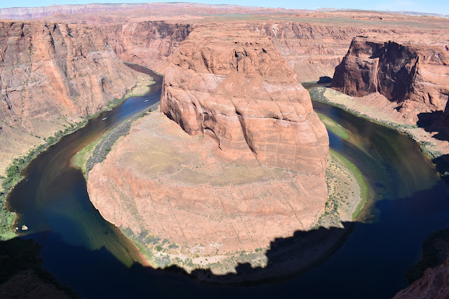
Horseshoe Bend & Grand Canyon
We left our motel at 8:00 under blue clear skies. It was cool all day today. Highway 89 took us south of Page a few miles to the Horseshoe Bend parking lot. From there we walked three quarters of a mile to the rim of the canyon where the Colorado River carved a giant horseshoe shape in the rock. It was very pretty but there were no guard rails or fence preventing people from falling in, which made me a bit nervous.
Hwy 89 then took us further south before we turned west onto Hwy 89A, which took us back north and then west across Marble Canyon and the Colorado River on the Navajo Bridge.

To see all the pictures taken at Horseshoe Bend and Navajo Bridge click on this link:
Bend&Bridge
Still on 89A we drove west and north to Hwy 67, which took us south to the North Rim of the Grand Canyon. The last time Chris and I tried to visit here Hwy 67 was closed due to snow. We had lunch at the Lodge on the North Rim before wandering around and taking a few photos. Chris and I did the short walk out to Bright Angel Point.

Our next stop was at Point Imperial, a view point at the north rim of the Grand Canyon. Besides the pretty views, it was less crowded and it was cool because to the northeast we could see Marble Canyon, where the Colorado River was approaching the Grand Canyon.

To see all the pics taken at the Grand Canyon click on this link: GrandCanyon
From the Grand Canyon we drove north to Kanab, UT, where we spent the night at a Best Western. We spent some time kibitzing with Carl and Marge in the hot tub (and the water was very hot) before calling it a night.

Comments